
Fly the Furrow: The Cairo-Baghdad Mail Route

The pair of Royal Air Force Vickers Vernon aeroplanes lumbered over the Jordanian desert, their huge noses pointing east, or so the few passengers hoped.
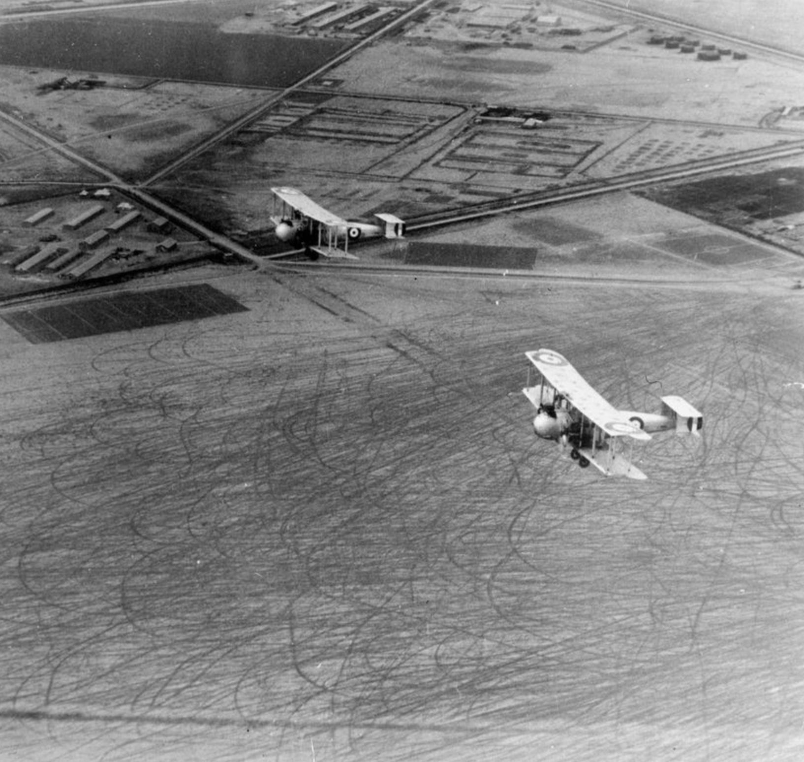
Every fortnight from 1921 to 1926, passengers would squeeze themselves into the cargo bays of two RAF biplanes in Cairo for a journey to Baghdad, via Amman. The first leg was easy enough with plenty of landmarks to navigate by, but on reaching Amman, these guests would discover that for the next leg onto Iraq their pilots had to fly over 500 miles of hard rocky desert, completely blind. With no reliable compasses available for pilots and no obvious landmarks below to make maps useful, it was just endless sand and rock. They could not ask their base for directions, as all the radio could manage was Morse code messages tapped out painstakingly letter by letter, but even those could only reach 180 miles and it was 470 miles to their next stop in Iraq. For all intents and purposes, they were heading into the unknown.
Yet somehow, despite all these limitations, just 12 hours later those great Vernons touched down at the aerodrome in Baghdad and their passengers disembarked, mystified as to how they got there. The fortnightly runs owed their success to a 1921 demand from a frustrated Winston Churchill.
The then Secretary of the State for the Colonies had demanded of officials an explanation as to why it took 28 days for him to send a letter from London to Baghdad, the capital of the Kingdom of Iraq, a post-Versailles British protectorate. At the time, the British Empire was at its widest territorial extent and speed of communication mattered. The recent invention of the aeroplane was seen as the solution with an airmail route quickly proposed that would reduce Churchill’s letter’s journey time to just nine days. From Baghdad, mail could travel onward to India and beyond to the empire’s farthest corners.
There was a significant issue with the plan, and that was the 860 miles between Cairo and Baghdad. Until the airmail route, letters travelled laboriously by train, car, and on occasion even camel. The problem was the 500 or so miles of hard rocky desert, largely between Jordan and Iraq.

As you can see, this stretch of desert is largely flat and featureless, a nightmare for pilots in the days before satellite navigation and effective compasses. It was in such a desert, in Libya, that my own grandfather crashed his biplane in the early days of World War II while trying to find his airbase and becoming completely disoriented in the process. If a plane got lost and went down in this kind of desert, it could take months to find it with few residents and even fewer travellers.
To come up with a solution, the RAF turned to a man who spent much of the 1920s mapping the Jordanian and Syrian deserts, Major A.L. Holt of the British Army’s Royal Engineers. Major Holt had a particular obsession at the time with creating a railway that would run from the Middle East to India1 and connect what he predicted would be two of the world’s most important regions. He saw the RAF mission as a chance to work on that passion project and while proposed railway was never built, Major Holt did design an ingenious plan to solve the issue of aeroplane navigation over the desert.
The engineer took two convoys of Rolls Royce armoured cars and supply trucks, each of about 10 vehicles, and set them each off from Amman and Baghdad respectively with the two set to meet halfway. The two convoys were given the objective of plotting a route for the RAF aircraft for them to follow from above. For months the two convoys worked surveying and mapping what features they could get out of the dry land, from highlighting thorn bushes to specific puddles of mud. By the end, Major Holt’s team had created 12 maps of the route and also found strategic water locations along the way. These maps were compiled into a handbook and issued to pilots to follow.


But even with maps, how could the pilots follow along in case they managed to lose the few landmarks they had? Major Holt decided to not just label the map but also label the ground itself. Every 20 miles on the route, soldiers and workers cleared a 20-yard circle and the circle labelled the ground by digging out large symbols - the Amman convoy used the letters A to R and the Baghdad Convoy the Roman numerals I to XI. Each of these both functioned as route guidance but also as landing sites. Aeroplanes then were not as reliable as today and would often have to land to fix mechanical faults or sit out nasty weather. Arrows even helped pilots make sure they were heading the right way and on target.
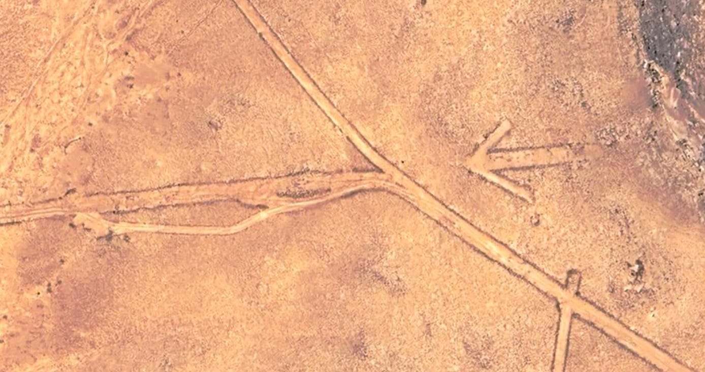
After Major Holt’s team was finished, tractors were brought in to dig the whole route as a deep furrow visible from above and entrenched enough to not be blown away. For ground too rocky to be dug out, it was marked with white paint. The route quickly acquired the nickname of “Flying the Furrow” and the furrow is still visible today both on the ground and from the air and satellite.

With the route mapped out, the service began in late June 1921, with the RAF charging 1 Shilling (around £2 today) per ounce2 of mail. The route was always operated by a pair of biplanes, if one had to land then its consort could pick up the passengers and mail and continue, sending help on arrival at the destination. If a plane needed to land, the pilot would use a pistol to fire a flare from the cockpit, with colours indicating the issue. Each aeroplane was loaded with several days worth of rations, blankets and 18 gallons of water just in case the 12 hour journey turned into something much longer.
The creators such as Major Holt and the RAF made clear that even with their hard work, it was now out of their hands, the Pilot Handbook3 reads: “The success of the route rests more in the hands of the pilots of aircraft operating on it than in the hands of those who are responsible for its inauguration and maintenance.”
It was a notoriously unpopular route for pilots, with the endless straight flying over featureless ground and regularly having to make desert lands becoming repetitive quickly. Wing Commander Roderic Hill, who wrote a book on the Furrow, kept himself going with pheasant and ham sandwiches washed down with a thermos of lemonade. The Pilot Handbook advises pilots that while they will be unlikely to find a bath or shower if forced to land, that instead a “brisk rub down with a dry towel (or shirt) at dawn will prove surprisingly refreshing.” Passengers were similarly uncomfortable, juddering along in the rudimentary cabin for 12 hours was quite the experience, probably compounded by the RAF guidance that paying customers should receive a “full saline and calomel purge,” to make them vomit.

The Pilot Handbook provided all sorts of guidance, from information on where emergency fuel caches were kept and how to deal with any interested locals, including some phonetic Arabic phrases. It insists that “No offer of food from Arabs should be refused, as such refusal is considered unmannerly,” and that “if a large body of Arabs insists on relieving you of arms or ammunition, the only course is to give them up with good grace.”
Besides carrying mail, the route had other benefits to the British Government. Much of its imperial enforcement in the Middle East was conducted from the air, due to the ease compared to road travel. Rebellions were put down in bombing runs and borders patrolled by aircraft like the Vickers Vernon cruising above the desert. The flights also trained RAF pilots and navigators in long distance flying without visual landmarks, a skill that came in use during the Second World War when some veterans of the Furrow, including Arthur ‘Bomber’ Harris held high office in wartime deciding overall strategy.
Regardless of its benefits, however, the Cairo to Baghdad Air Mail route was a phenomenal money loser for the RAF and in 1926 they handed over its administration to Imperial Airways, the predecessor of British Airways, who operated it as a weekly service. By then, there were more than 25,000 miles of air routes across the British Empire operated by the airline, but the Furrow remained crucial to those 500 miles between between Jordan and Iraq till technology caught up. While today it remains visible if you look hard enough, aeroplanes now travel far above it, following instead a virtual furrow on their navigation screens.

I am very grateful to my friend Colonel Will Davies MBE, the UK Defence Attaché in Amman, for first alerting me to the existence of the Furrow and also for photographs from his visit which he has kindly shared.
Brilliant one! I follow this newsletter for this kind of stories that are not 'trending' but bring the best of internet to one place.
I wonder how do you even come up with such topics and do research around them?
Reminds me of the huge numbers of 70 ft concrete arrows dotted across the US as navigation aids for the Transcontinental Airway System.
(When the system was in use, the arrows were accompanied by steel towers with lights, but these were dismantled for scrap during WW2).